

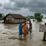


In the third week of July 2026, Upper Assam faced one of its most intense flood episodes in recent memory. Exceptionally heavy rain over parts of Nagaland and the foothills of Assam sent tributaries of the Brahmaputra surging at unusual speed. Within days, water swallowed villages, fields, and roads. By late July the official death toll had reached 68, and more than four to five lakh people were still dealing with the aftermath even as waters began to recede.
What the Numbers Showed in Late July
As of 27–28 July 2026, the Assam State Disaster Management Authority (ASDMA) reported roughly 4.45 lakh people affected across six districts: Sivasagar, Golaghat, Charaideo, Jorhat, Nagaon, and Kamrup (Metropolitan). Charaideo remained the hardest hit, with nearly 1.88 lakh people impacted, followed by Sivasagar (about 1.44 lakh) and Jorhat. Earlier peaks had exceeded 6.5 lakh people across a wider set of districts.
Around 630–760 villages stood under water at different points in the crisis. Crop damage covered approximately 37,000–48,700 hectares. Tens of thousands of people stayed in relief camps (about 28,700 in the later figures), while many more received aid through distribution centres. Livestock losses were heavy, with reports of more than 26,000 animals washed away and over two lakh animals affected in total. The Dhansiri (South) at Numaligarh continued to flow above the danger level longer than most other rivers.
Rescue teams from the Army, NDRF, SDRF, fire services, and local administration used boats and other means to reach cut-off areas. Embankments, roads, bridges, and power lines suffered widespread damage. Authorities later shifted emphasis to rehabilitation, power restoration, and helping families return home.
Other Blog : Why Dharmendra Pradhan Resigned: The Full Story Behind the Education Minister’s Exit
Why This Flood Hit So Hard
Assam’s vulnerability is built into its landscape. Nearly 40 percent of the state’s area is flood-prone—roughly four times the national average. The Brahmaputra is one of the world’s most sediment-heavy rivers. It carries vast quantities of silt and sand from the young Himalayas and the Tibetan plateau. When the river enters the flatter Assam plains, it slows down, drops sediment, and gradually raises its own bed. This reduces the channel’s capacity to hold monsoon water.
The 2026 event was driven by intense upstream rainfall. Parts of Nagaland and Assam recorded rainfall departures of 400–500 percent above normal over short periods. Tributaries such as the Dikhow, Disang, and Dhansiri rose rapidly. When the main Brahmaputra itself runs high, these tributaries cannot drain freely; water backs up and spreads across the floodplains.
Other long-term factors amplified the impact:
- Deforestation and land-use change in the upstream hills of Nagaland and neighbouring areas increase runoff and soil erosion.
- Ageing embankments, many built decades ago, frequently breach or fail under pressure. While they protect some areas, they also trap silt inside the river channel and can worsen flooding when they give way.
- Climate trends are producing more intense, concentrated rainfall bursts rather than evenly spread monsoon rain.
- Settlement patterns and reduced natural wetlands leave less space for water to spread harmlessly.
The 1950 Assam earthquake had already altered river courses and raised bed levels in parts of the valley; decades of human activity have added further pressure on an already dynamic system.
The Human and Economic Cost
Beyond the death toll, the floods disrupted daily life across large parts of Upper Assam. Families lost homes, stored grain, and livestock. Agricultural land under water threatens the coming season’s harvest and the livelihoods of farming communities. Infrastructure damage slows recovery and connectivity. Relief camps provided food, shelter, and basic care, including support for pregnant women, children, and people with disabilities, but living conditions in temporary shelters remain challenging.
Power supply was suspended in many places as a safety measure and later restored in phases after inspections. Local and state administrations, supported by central agencies, coordinated rescue and relief. Political leaders described the event as among the most severe in decades and called for focused rehabilitation.
Looking Beyond Immediate Relief
Assam will face floods again. The question is how much of the damage can be reduced. Experts and officials point to several directions that matter:
- Stronger, more localised early-warning systems that give people hours rather than minutes to move.
- Better management of upstream catchments through reforestation and controlled land use.
- Rethinking embankment strategy—maintenance, strategic realignment, and improved drainage sluices rather than simply building more walls.
- Protecting and restoring natural wetlands and floodplains that once absorbed excess water.
- Climate-resilient planning for housing, agriculture, and infrastructure in high-risk zones.
The 2026 floods were not an isolated accident of weather. They were the product of geography, a sediment-laden river system, extreme rainfall, and decades of cumulative human influence on the landscape. Recovery is underway, but lasting safety will require treating the Brahmaputra basin as a living system that needs careful, coordinated management rather than purely reactive control.
For the most current official figures, the Assam State Disaster Management Authority remains the primary source. Communities in the affected districts continue to need practical support as they rebuild.

One comment on “Assam’s 2026 Floods: When the Rivers Rose Faster Than the Warnings”